The Surfer Dude and Stormmaster G

The Surfer Dude and Stormmaster G–Part IV
(09/11/2009)
surfer-IV

This is the fourth and final part of “The Surfer Dude and Stormmaster G,” an excerpt from Inside The Weather Channel. Next week I’ll begin a series taking you behind the scenes of “Your Weather Today,” the Weather Channel’s popular morning show, as it was in late 2008 with Marshall Seese and Heather Tesch.

THE SURFER DUDE AND STORMMASTER G
Two of the Best Reasons to Watch The Weather Channel–Part IV

The Weather Channel’s severe weather expert, Greg Forbes, like the network’s hurricane expert, Steve Lyons, sees his first duty to the public as opposed to The Weather Channel. The channel, however, plays an extremely important role in what both he and Steve do. It’s the vehicle for getting their warnings disseminated. For saving lives.

STORMMASTER G

Greg, known around the office as “StormMaster G,” joined The Weather Channel in 1999 after spending 21 years on the faculty at Pennsylvania State University. He earned his Bachelor’s Degree in Meteorology at Penn State before venturing away from Keystone country to the University of Chicago. There he studied under Dr. T. Theodore Fujita, perhaps the most recognizable name in the field of severe thunderstorms and tornadoes.

Dr. Fujita, along with Allen Pearson, developed the now widely-used zero through five scale of tornado intensity. It’s since been refined and is now known as the Enhanced Fujita Scale. These are the EF ratings assigned to tornadoes.

Greg was awarded his Master’s and Doctorate from the University of Chicago. He returned to Penn State in 1978 to begin his teaching and research career at the university. Since then, his work has taken him across much of the world. He’s dogsledded under the Northern Lights in Sweden and worked with the national weather services of South Africa, Spain and the Netherlands. (In the Netherlands, ironically, he watched a small tornado churn through his backyard.) He’s also the only member of the prestigious National Academy of Science’s Board on Atmospheric Sciences and Climate who’s a broadcast meteorologist.

A couple of things you might not know about Greg: he was first chair clarinet in his high school band–apparently no threat to Benny Goodman; and he used to drive muscle cars, Pontiac Firebirds. (You should have hung onto them, Greg, now that they’ve gone the way of Packards and Studebakers.)

Greg is a tireless worker. I never put a clock on him, but it seemed to me he spent as much time at The Weather Channel as he did at home. He doggedly turned out five-day outlooks for severe thunderstorm activity across the country. But because of the inherent uncertainty in severe weather crystal-balling, The Weather Channel did not–and does not–specifically depict such threats beyond two days into the future. On-camera meteorologists, however, may verbally mention the risks.

Bespectacled, balding and slight of build, Greg looks the part of a college professor. He’s rather reserved, but possesses a fine sense of humor. And he’ll engage you in spirited conversations about his passions: severe weather and Pennsylvania sports teams. He’s an especially big fan of the Pittsburgh Steelers (football) whose training camp is in his hometown of Latrobe, the Pittsburgh Penguins (hockey) and of course the Penn State football team. Greg has a football autographed by the Nitanny Lions’ venerable coach, Joe Paterno.

On the morning of February 1, 2009, I couldn’t resist testing Greg’s sense of humor. In a telephone call to him, I tried to play up the low-end threat of severe thunderstorms in eastern Texas later in the day, suggesting he might be needed on the air. Of course, I was well aware that nothing short of a swarm of EF-5 tornadoes would get Greg into the office that particular Sunday. His beloved Steelers were playing in Super Bowl XLIII, and odds were he’d already barricaded himself in his house with chips, dips and beverages. But I just had to rattle his cage.

Naturally, he didn’t take the bait. His knowledge of violent thunderstorms and tornadoes rivals Steve’s encyclopedic understanding of tropical storms and hurricanes, and he knew from the get-go I was jerking him around. It turned out to be a good day for Greg. The Steelers won the Super Bowl and only a handful of hail-producing storms popped up in eastern Texas. There was one report of a possible brief tornado. No damage occurred.

Greg’s biggest fear regarding tornadoes is that one will someday strike a major sporting event with little warning, giving people no time to find shelter. A great many baseball games, automobile and horse races, NCAA basketball tournaments (March Madness) and even some football games are held during seasons when twisters prowl the landscape. Atlanta experienced a close call in March 2008 when an EF-2 twister slashed through the downtown area on a Friday night as a Southeastern Conference basketball tournament game was in progress at the Georgia Dome. The dome was only slightly damaged and no one inside was hurt, but there was one fatality on the streets of the city.

Greg points out that weather-related events don’t cause nearly as many deaths as traffic accidents, so you needn’t live in constant fear of nature’s wrath. But you can certainly improve your odds of survival should you ever find yourself in the crosshairs of a severe storm by remembering a few simple rules. Stay indoors or in a hard-topped motor vehicle during thunderstorms. Don’t drive on flooded roadways. If a tornado or damaging windstorm is imminent, seek shelter in the lowest, innermost portion of a sturdy home (not a mobile home) or building.

And, of course, pay close attention to whatever StormMaster G is saying on The Weather Channel. He’s the Magic Man when it comes to issuing heads-up for severe weather.

Photo: Beaver Stadium, Pennsylvania State University
Greg Forbes, The Weather Channel’s severe weather expert is a Penn State grad and former professor.  He has a football autographed by the Nittany Lions’ venerable football coach, Joe Paterno.

The Surfer Dude and Stormmaster G–Part III
(23/10/2009)
surfer-III

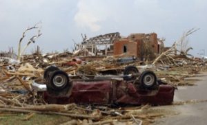
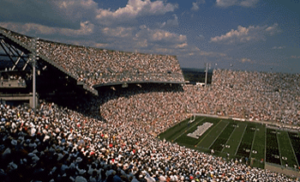
Here’s part III of an excerpt from INSIDE THE WEATHER CHANNEL, “The Surfer Dude and Stormmaster G.”

THE SURFER DUDE AND STORMMASTER G
Two of the Best Reasons to Watch The Weather Channel–Part III

THE GREENSBURG MONSTER

Mid-afternoon, May 4, 2007. The Weather Channel’s severe weather expert, Dr. Greg Forbes, is concerned. The NWS’s Storm Prediction Center has issued an outlook for the following day calling for widespread severe thunderstorms, some with tornadoes, over the central and southern Great Plains. It’s drawing a lot of attention. But Greg sees a more immediate, perhaps dangerous, threat erupting within the next few hours and wants to maintain a focus on that.

His heart thumps a little more rapidly as he examines the current meteorological charts and upper-air parameters. Something he’s seen before is emerging, something ominous: the “first punch” of a developing severe weather situation that often turns out to be more devastating than what follows. It’s as if he senses a dark cloud slithering across his psyche.

He takes a deep breath and continues to study the data. Warm, humid air from the Gulf of Mexico is flooding northward into Kansas; a dry line, marking the leading edge of a dry air mass, hovers over the western portion of the Sunflower State; aloft, a large trough of low pressure over the Great Basin has unleashed a dagger of powerful upper-air winds into the region. It’s a classic set up for particularly destructive twisters. Greg realizes lives may be at stake.

He goes on the air and points out the peril, outlining a small area for a dangerous tornado outbreak later that afternoon and evening: western Kansas. By early evening, reports of twisters are coming in from northwest Oklahoma and southwest Kansas.

Around 8:30 p.m. CDT, a particularly nasty looking storm begins to unleash funnel clouds and tornadoes over the open prairie of Clark County, Kansas, just north of the Oklahoma border. On Doppler radar, Greg begins tracking the thunderstorm that’s triggering the twisters. His sense of dread increases as he watches the storm, what’s known as a supercell, slice northeastward. Around 9 o’clock, he warns that the town of Greensburg in Kiowa County may be in the path of the storm. Forecasters in the Dodge City, Kansas, NWS office have their eyes on the cell, too. They issue a tornado warning for Kiowa County at 9:19 p.m and mention that Greensburg may be in danger.

Greg’s stomach knots as he sees the thunderstorm intensify rapidly as it nears Greensburg. The strength of its rotation increases dramatically; a classic hook-shaped radar echo, the signature of a tornado, emerges. Storm chasers and spotters begin reporting a large tornado, perhaps a mile wide, just southwest of Greensburg. In the business, such a twister is called a “wedge,” because it takes on the appearance of a massive, black triangle with its apex embedded in the ground. The wedge is 20 minutes from Greensburg.

At this point, the NWS declares a “tornado emergency” for the town. A tornado emergency is a strongly worded tornado warning that’s issued whenever a large, particularly violent twister is expected to hit a populated area.

Greg thinks the huge tornado will smash through the southeastern side of Greensburg. On camera, his warning, reflecting his anxiety, tumbles out like a waterfall. Then the situation grows unimaginably worse. The supercell veers toward the center of Greensburg. In the blink of an eye, it’s become a nightmare scenario.

The massive twister is screened by large hail and heavy rain that hammer the town first. The wedge is now over a mile and a half wide and Greg realizes that residents will never see it coming.

In the darkness, only strobes of lightning illuminate the apocalyptic storm as it levels the town.
“I had done all I could,” Greg said later, “but still a feeling of helplessness was there. I wished that I somehow could have moved every citizen out of harm’s way.”

Still, that evening, he harbored the dim hope that the tornado might lift–dissipate–at the last second before reaching Greensburg. As he came back on the air at 10 p.m. after a commercial break, he knew that hadn’t happened. Reports from spotters indicated the tornado had made a direct hit on the tiny town.

“After I reported that,” he said, “[on-camera] meteorologist Paul Goodloe asked me what advice I would give to people in the area. It nearly choked me up. I advised people north and northeast of Greensburg to take shelter. Deep down, what I felt, though, was that prayers were in order.”

Greg slept fitfully that night, knowing what dawn was likely to bring.

And what it brought was confirmation of 11 fatalities and that 90 to 95 percent of Greensburg had been flattened. Quite literally. In fact, Greg was amazed the death toll wasn’t higher. “I could only hope I helped saved some lives,” he said.

Photo: Greensburg, Kansas, May 5, 2007.
90 to 95 percent of the town was destroyed by a massive EF-5 tornado the previous evening.  (Photo from Adjutant General’s Office, State of Kansas.)

The Surfer Dude and Stormmaster G–Part II
(09/10/2009)
steve

Following is Part II of The Surfer Dude and Stormmaster G, an excerpt from INSIDE THE WEATHER CHANNEL, a work in progress. Part III will appear in a couple of weeks.

THE SURFER DUDE AND STORMMASTER G
Two of the Best Reasons to Watch The Weather Channel–Part II

PAY ATTENTION TO WHAT ISN’T BEING SAID

On the air, Steve Lyons sometimes treads a fine line when he doesn’t agree with a NHC forecast. He’ll never say explicitly that he thinks the Hurricane Center is wrong. So as a viewer, you have to learn to read between the lines. And that means paying attention not so much to what he says as to what he doesn’t say, or show.

In June 2005, prior to Dennis slamming into the Florida Panhandle in July, Tropical Storm Arlene was swirling toward the eastern Gulf Coast. The NHC ordered hurricane warnings hoisted from Pascagoula, Mississippi, to Destin, Florida, as the storm neared the shoreline. Steve didn’t think the storm had a prayer of delivering hurricane-force winds. But he didn’t say that on his broadcasts. Instead, he just ignored the warnings, not referring to or showing them. He pointed out there would be possible tree damage and power outages, but that was it.

He was right. Sustained wind speeds along the coast barely reached tropical storm force. The peak gust recorded was 60 mph, well below hurricane force, at the Navarre Fire Station.

That’s the key to watching Steve: be aware of what he doesn’t say or emphasize. If he thinks strong winds are not going to be an issue or that hurricane warnings are overblown, he won’t dwell on them. Many times he’ll zero in on heavy rain and flooding or coastal water rise as being the most dangerous aspects of a storm.

Steve, who arrived at The Weather Channel in 1998 after a job at the NHC, understands the pressure and scrutiny the forecasters there operate under, so isn’t looking to poke fingers in their eyes. If fact, had Steve remained at the Hurricane Center, he would have been a strong candidate to become the unit’s director. But in whatever capacity he serves, he has a well-defined philosophy about what’s right and what’s not, what works and what doesn’t and what’s important and what isn’t.

For one thing, he isn’t particularly enamored of the forecasts made by several organizations, including the NHC, for the number of Atlantic Basin tropical cyclones expected each year. The tally, he grouses, has an extremely low correlation to the number of hurricanes or tropical storms that smack the U.S. In 2001, for example, there were 15 Atlantic tropical cyclones, but not one hit our shorelines. In contrast, just six named storms and hurricanes popped up in 1992, but one of them was the infamous Category 5 Andrew that leveled Homestead, Florida. “So what’s the point of the forecasts?” Steve asks. “People who live along the Atlantic and Gulf Coasts should be prepared every year for a hurricane.” It only takes one to wipe out everything you own, including your life.

WE’VE GOT 10,000 BODY BAGS

One thing Steve likes to do is talk at random with people who live in cities vulnerable to hurricanes. He did this in New Orleans prior to Katrina in 2005 and discovered how woefully unprepared The Big Easy was. He wandered into a McDonald’s and ordered a soft drink; he asked the young woman serving him if she would evacuate if a hurricane were threatening the city. Without missing a beat the gal responded, “What’s a hurricane?”

“I still wonder what became of that girl,” Steve says.

As in past years, his informal survey suggested that about 40 percent of the people he chatted with wouldn’t evacuate even if they knew a hurricane was coming.

But the unpreparedness didn’t end with the general populace. Steve asked an emergency manager what the evacuation plan was for the city. “We got 10,000 body bags,” the manager said.
Steve thought he’d been misunderstood and repeated the question.

“We got 10,000 body bags,” the man said again.

I suppose that’s one way of evacuating a city, but not the preferred method.

Steve’s biggest fear, his doomsday scenario, so to speak, is of a hurricane undergoing unexpected rapid intensification just before making a predawn landfall in a major coastal city. Millions of people could be put at risk if they, for instance, went to bed anticipating a low-end Category 2 hurricane and awoke to discover a Category 5 beast bearing down on them.

It’s not an idle concern. In the same year that Arlene, Dennis and Katrina plagued the Gulf Coast, a system in the northwest Caribbean Sea, Wilma, evolved from a 70-mph tropical storm to a 175-mph Category 5 killing machine in just 24 hours. Or putting it into the perspective of Steve’s nightmare scenario, in a mere 12 hours it jumped from a “run-of-the-mill” Category 1 hurricane to a catastrophic Category 5. It exploded from a Cat 1 to a Cat 4 in a meteorological blink of the eye: six hours. Such rapid strengthening was unprecedented. But we know now it can happen.

FIVE TOES

Steve reminds his viewers, and readers of his blogs, over and over not to get hung up on a hurricane’s category, the numerical rating provided by the Saffir-Simpson scale. The Saffir-Simpson scale was designed to rate only the wind damage potential of hurricanes. But it’s been expanded, not particularly successfully, to include storm surge potential.

There are many factors, not just hurricane intensity, that determine surge levels: the character of the coast (its shape and offshore slope), the forward speed of the hurricane, its size, its track, and the angle at which it strikes the shoreline.

Steve also doesn’t like to focus on surge alone. He’s more interested in what he calls water rise, which takes into account not only the tidal surge caused by the storm, but the wave height, as well.

He offers the following examples. In 2008, Hurricane Ike, a Category 3, slashed over Galveston Island bearing a 15- to 20-foot water rise. A typical Category 3 surge is listed at 9 to 12 feet. But there are more striking (and deadly) examples. Katrina, also a Cat 3, slung a 24- to 28-foot wall of water, over twice as high as the surge listed for a Cat 3, into the Mississippi coast.

Sometimes, the water rise is considerably less than would be expected for a particular category. In 2004, small but intense Charley, a Category 4 buzz saw, ripped into southwest Florida near Fort Myers. The standard surge for a Cat 4 is listed as 13 to 18 feet, but a water rise of just 6 to 8 feet was realized from Charley. And 1992’s Andrew, a Category 5 brute, smacked Florida’s southeast coast with a water rise of 14 to 17 feet; the Saffir-Simpson scale, however, lists the expected surge with a Cat 5 as being in excess of 18 feet.

Thus, the surge heights listed on the Saffir-Simpson scale offer only a rough, and sometimes extremely misleading, guide. Better to pay attention to Steve and his water rise forecasts.

More to the point, you shouldn’t get hung up on a hurricane’s category. The Saffir-Simpson ranking gives the media a simple, easy method to describe the strength of a hurricane, but what you need to pay attention to are the overall impacts of the storm.

Steve points out that much more important than the Saffir-Simpson rating of a hurricane are the “five toes,” or expected impacts, of its footprint: wind speed, rainfall, offshore waves, water rise, and its so-called baby toe, tornadoes. In the real world, the category of a hurricane relates very poorly to some of these toes. Inundating rainfall and its resultant flooding, for example, can sometimes be more damaging and deadly than anything spawned by high winds or water rise, especially in weaker hurricanes.

Steve sometimes gets miffed when the media, including occasionally The Weather Channel, makes a big deal out of a hurricane strengthening from one category to the next. Often, that means the wind speed increased only 5 mph. “So what?” our AARP surfer dude asks rhetorically in those situations, “What’s the difference between a strong Cat 3 or low-end Cat 4?”

So it comes back to impacts, impacts, impacts.

And, oh yeah, don’t forget to pay attention to what Steve doesn’t say at times. Bottom line: he knows what he’s talking about… and not talking about.

Photo: Dr. Steve Lyons
Tropical weather expert Steve Lyons at work in The Weather Channel’s HD studio.

The Surfer Dude and Stormmaster G–Part I
(30/09/2009)
surfer-I

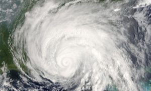
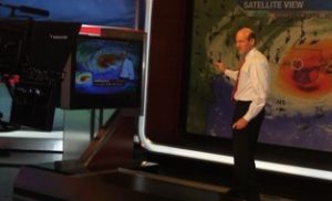
Following is Part I of “The Surfer Dude and Stormmaster G,” an excerpt from INSIDE THE WEATHER CHANNEL. Next week, Part II.

THE SURFER DUDE AND STORMMASTER G
Two of the Best Reasons to Watch The Weather Channel–Part I

Early morning, July 10, 2005. Extremely dangerous Hurricane Dennis, centered about 245 miles southeast of Biloxi, Mississippi, and packing sustained winds of 145 mph, is charging toward the eastern Gulf Coast. Hurricane warnings blanket the shorelines of Mississippi, Alabama and the Florida Panhandle. With Dennis on a steady north-northwest track, Mobile, Alabama, appears to be ground zero for the violent storm’s landfall.

By mid-morning, the Category 4 hurricane wobbles to the right, taking a more northerly course, but shortly thereafter resumes its sweep toward the north-northwest.

THE WEATHER CHANNEL IS TOAST

In The Weather Channel operations area, Dennis’s wobble has Dr. Steve Lyons, the channel’s tropical weather expert, and Stu Ostro, Senior Director of Weather Communications, in an animated discussion. Stu is the team leader of the network’s experts, so has a vested interest in what goes on the air. Steve, as always, just wants to get it right. “I work for the public,” he says, “even though The Weather Channel pays me.”

Both Steve and Stu have been up for hours. Stu is bleary eyed and scruffy, having slept only an hour and a half–on the floor of his office–the last two days. Dennis’s little jiggle has both men concerned. Mobile may no longer be in the storm’s crosshairs. With the eye of the hurricane so close to the coast, its target could now be as far right (east) as Destin, Florida.

At issue is how much to adjust Dennis’s projected swath, the cone that’s displayed on the air. It’s a matter that has not only public safety ramifications, but political ones, as well. While not bound by National Hurricane Center (NHC) forecasts, The Weather Channel remains sensitive to not over-emphasizing differences. Steve and Stu are apprehensive about making a radical change to the hurricane’s forecast path at this late hour, but realize some adjustment is mandatory.

The biggest worry is whether to remove Mobile from the forecast swath. The thinking is that it would be almost impossible now for the eye of Dennis, only miles from the coast, to hook left far enough to strike the city before making landfall.

Still, Stu is circumspect about taking Mobile out of the zone of greatest danger. “If we do and the hurricane swings back to the left and hits the Alabama coast,” he says, “The Weather Channel is toast. There’d be an investigation that goes all the way to the governor.” He gives a thin, sardonic smile. “Hell, governor?” he mutters, “All the way to the White House.”

Well, maybe not. But the comment shows how seriously the channel takes the business of getting things right, especially in life or death situations.

In the end, for political (cover-your-ass) reasons, Steve and Stu agree to leave Mobile in the cone of uncertainty on the extreme left or western side of the swath. The right flank is shifted eastward to Ft. Walton Beach. On-camera meteorologists are able to verbalize immediately, even before the cone can be updated for broadcast purposes, that the bull’s-eye for Dennis’s landfall appears to have shifted into the western part of the Florida Panhandle. NHC comes out with its altered swath, essentially mirroring what Steve and Stu came up with, an hour or two later.

The eyewall of Dennis thunders ashore at mid-afternoon near Navarre Beach, Florida, about halfway between Pensacola and Ft. Walton Beach. The storm has “weakened” to a Category 3, but wind gusts still peak at 121 mph. Mobile is spared a direct hit. Winds there remain below 50 mph, although the Battleship Alabama in Mobile Bay records an unofficial gust of 77 mph.

THE SURFER DUDE

I suppose no one at The Weather Channel is indispensable, but the person who comes the closest is Steve Lyons. Ratings soar when hurricanes prowl the U.S. coastline, and at the center of the action you’ll always find Steve. He’s devoted his professional life to the study of weather and waves. Growing up in San Diego, he was an avid surfer and grew curious about what caused large breakers. Eventually, his study of waves led him to research in a phenomenon that produces some of the biggest waves on earth, hurricanes. He earned his Bachelor’s, Master’s and Doctor’s Degrees in Meteorology at the University of Hawaii. He’s a Fellow of the American Meteorological Society and has published more than 60 scientific papers and technical reports.

Steve was awarded a track and field scholarship by the University of Hawaii and was a world-class runner in 400- to 800-meter events, although he competed in races as long and as grueling as marathons. His friar’s fringe of hair is about the only clue he’s tiptoed into AARP territory–that’s age 50 or over for you youngsters. He remains trim and fit, bicycling, running, snow skiing, golfing and yes, even surfing when he gets the chance.

Golfing? Steve says his short game is abysmal, but in 2007 at the annual Weather Channel (Hackers) Golf Tournament, he blew all the young bucks out of the water by winning the long drive award.
Despite his love of sports, Steve still finds plenty of time–but not enough, he says–to spend with his family, including his three dogs, a whippet and two Italian greyhounds. Hmmm. Whippet. Greyhounds. Former track star. Also drives a Porsche. Are you beginning to see a pattern here? A need for speed? That’s probably what got him into a University of Washington’s wind tunnel to experience 160-mph (Category 5) winds. The event was “just horrible” he recalls. “It was one of the worst things I’ve done in my life.” He suffered a broken rib and two black eyes even though he wore a protective helmet and a restraining harness.

Steve is a bit too mature to be referred to as “dude” these days, but his love of surfing is still there. And there’s probably no one better at being able to predict surf action and the related phenomena of wave heights and storm surges. It’s not only in his blood, it’s in the comprehensive models he’s developed. Steve can crank out a spot-on surf forecast for anyplace in the world faster than you can say, “Wax ‘em up.”

Steve is outgoing, intense and confident. He’s always ready with a smile and a “good morning” when he bounces into work. (He’s probably been listening to Jackson Browne on his car stereo.) When he’s on-task, whether at work or play, his concentration is fierce. There were times when I went to his desk to ask a question. Not wanting to disturb whatever he was focused on, I would stand silently by for several minutes waiting for him to realize I was there.

Even when he’s having fun, he can get tunnel vision. A number of years ago, Steve and his wife were vacationing in Cancun. Steve decided to take advantage of some four- to five-foot waves and do some body surfing. It was a beautiful day, he said, with blue-green swells rolling in off the Gulf of Mexico and puffy white cumulus dotting an azure sky. Except for another surfer maybe a hundred yards away, of whom he took only casual notice, he had the water to himself. Time and time again he rode the curl of Gulf breakers into the beach.He’d finally had enough. He climbed out of the surf and walked back to where his wife awaited on the sand.

“There was another person out there,” she said.

“Yeah,” Steve responded, “I had the place pretty much to myself. Great surf.”

“You didn’t notice?”

“Notice what?”

“The other person.”

“Not really,” Steve said. He turned to look, but whoever had been in the water with him was gone.
“She was naked,” his wife said.

I wouldn’t have believed that story from anyone but Steve.

While he has a wonderful sense of self-deprecating humor, don’t let that fool you. Just below the surface he’s supremely confident. That’s because, to put it simply, he’s the best at what he does. He doesn’t boast. He just knows it.

Photo: Hurricane Dennis 2005
Hurricane Dennis making landfall near Navarre Beach, Florida, July 10, 2005.  (NASA imagery)